Friday, November 6, 2009

Washington Monument, Flags, 2009

This is my favorite photograph of the trip.
I had stopped by the White House and WWII Memorial and was walking past the Washington Monument when I noticed the flags in the breeze and the detail on the exterior stones. Even the shadows of visitors (wispy from movement) add to the image.

Franklin Delano Roosevelt Memorial

I had never visited the FDR Memorial. I walked there after passing the Jefferson Memorial. Not being familar with the FDR Memorial, it wasn't until I looked it up on the NPS website that I realized I entered the memorial at the exit.

Seeing the FDR memorial at night is not seeing it at its best. Certain "rooms" (four in all, one for each FDR term) are not fully lit, but other features are. One striking feature is the "final" (for me, however, the first) waterfall. It is in the "third" room, which symbolizes the WWII period. The water fall, the NPS says, is symbolic of the destruction of war, with blocks of granite chaotically strewn across the floor near the falls. I, of course, saw conveniently placed solid objects. I suppose I'll have to go back in the daylight.

Capital Building, East View, October 2009

I had not been to Washington after the construction on the visitor center completed. It has been several years since I was able to walk this close to the east side of the capital. I braced the camera on a barrier and felt fortunate to find a solid object

Capital Dome, West View, October 2009

Last month I found myself in Washington on business but the evening were free so I wandered the monuments and memorials along the national mall, with my camera, of course. I've found the national mall and the Capital Building area to be crowded - like a busy day at Disney World - during the day. At night, it was quite deserted (except for the other photographers and the Park Police).

Unfortunately, I could not find my small tripod before leaving on this trip so I had to make due with timed exposures while the camera rested on a solid object. Some of these series of photographs (this and the next four posts) obviously rest on an object. The solid object here was a park bench along a walkway on the mall side of the capital.

Tuesday, September 8, 2009

Mount LeConte, Afternoon Clouds, Late Summer 2009


I was lucky enough to find myself in Sevier County today on business. Between meetings, I drove the Gatlinburg "bypass" to my favorite Mount LeConte overlook. For the day after Labor Day, the weather was warm (84) but pleasant. As the image demonstrates, the clouds were thick, but full of character.

I've said the middle of the afternoon is usually not a great time for landscape photographs but there are always exceptions. The point I was trying to convey was not so much the details of Mount LeConte, the clouds obscured the peaks anyway and moving the camera angle any lower would have included in the image some unsightly weeds that have grown up over the summer. Taking what was offered, I focused on capturing the contrasts in the summer clouds without worrying too much about the exposure on the mountain.

Because it was the afternoon, the overall contrast in the clouds was low; the original image is quite flat. I chose this one (out of the several rather good potential images) because the exposure captured the sunlight on Mount LeConte without over-exposing the brightest spots in the clouds.

Sunday, August 30, 2009

Abrams Falls, Summer 2009 - Close Up

This is from the same hike I wrote about yesterday. One benefit of hiking "off-peak" is that it is easier to obtain good photographs from angles that would not otherwise be available. Sure, lots of folks walk to the edge of the flat rock and have their photo taken with the falls behind it. But setting up a camera on a tripod on a smallish and crowded rock isn't something I'll do. Folks come to Abrams Falls and the Smokies to see the beauty, not to watch out for guys with tripods.

I've always found the hike to Abrams Falls a bit of a downer. It isn't the view or the trail that is at fault. It is just that it is a short hike to a popular destination. On the "easy" trails, you come upon a lot of folks who act as if they still live in their insular "city" surroundings. Many don't acknowledge your existence, much less respond to a hello. Some are flat out rude, acting as if you are trespassing on their property.

One of the things I like about hiking the more demanding trails is that more folks will say hello, some will even stop and talk to you. It's kind-of an unwritten rule for the "serious hikers club." Another unwritten rule is to not let the rude hikers spoil the experience.

Before digital cameras were popularly available, I used to hike with a 4 x 5 field view camera, the kind you have to crawl under a cloth to compose and focus. Several photographs I've previously posted, of Anthony Creek, Mount LeConte, and Ramsey Cascade, were taken with it. It was a not just a great camera, fun to use, it sparked a number of nice conversations with serious hikers curious about the "old fashioned" camera. Some days I wish I had a digital camera that looks like a 4 x 5 field view.

This is another less than easy photo to create. It was digitally converted to black and white and then the contrast was enhanced. To get definition in the darker areas without losing luminosity in the falls, I had to give a little on the brightest parts of the falls. As a result, portions of the water are untextured white. I don't mind this as long as the white portions aren't too obtrusive.

Saturday, August 29, 2009

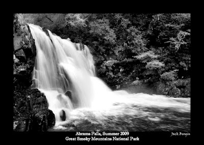
Abrams Falls, Summer 2009


By late August 2009, most of the East Tennessee schools have started back causing the weekday crowds in the Smokies to lighten up. I took the opportunity to hike to Abrams Falls in Cades Cove. I tend to avoid Cades Cove but only because it is over-used and I run short on patience in traffic jams.

The hike to Abrams Falls, 2.5 miles (one way), is moderate only because there are several short climbs along the way. Most of the trail was flat, wide and well-worn. The Park closed this trail for several days earlier this summer due to bear activity. We did not see any bears while hiking but several other hikers reported seeing bears on the trial. We certainly saw signs of recent bear activity.

The falls are extremely popular especially when it is hot and I have, in past trips, had to wait a while before I could take a photograph that did not have a person standing next to the falls. If this hike was any indicator, the time when Abrams Falls is least populated (but still very popular) is mid to late morning. We didn't have the falls all to ourselves at any point but there were only a handful of folks there until just before we left. On the way out, we met a good number of hikers (many wearing swimsuits) so avoid the latter parts of the day if you hope to take unpopulated photographs of Abrams Falls.

I have to admit I've always found Abrams Falls to be a difficult subject. Aside from the crowds there have been times when fallen tree logs leaned into the falls. I find it difficult to derive a satisfactory balance between the light on the falls and the wooded area above the falls. This photograph was better than any others I have taken but I am still bothered by the bushes above the right side of the falls.

This photograph was taken from the trail side of the pool. I also tried taking several photographs standing in the pool of water down river from the falls. (Thank goodness the water was warm.) Perhaps next time I will try to take photographs on the far side of the pool.

Saturday, June 20, 2009

Jack Mountain, Clouds, 2009


Jack Mountain lies east of the North Cascades National Park. This image, taken later in the day as the one of Kangaroo Ridge in the prior post, was actually taken from the Ross Lake National Recreation Area. Ross Lake lies on the eastern side of the North Cascades. Ross Lake and the North Cascades were created at the same time (legally speaking) but is separate from the national park, presumably because there are several power generating facilities within Ross Lake (the Skagit River Hydroelectric Project) which predated the creation of the national park and recreation area.

While Jack Mountain lies within the Mount Baker Snoqualmie National Forest, this view is from the Diablo Lake Overlook within Ross Lake. There are a number of overlooks/pullouts along the North Cascades Highway but this is the largest and has views of several peaks (those images will follow in later posts) and the deep green Diablo Lake.

We stopped at Diablo Lake Overlook twice, the first time, the sun was low enough on the horizon so that any photo of Jack Mountain from Diablo Lake included flares. Later in the day (around 3 to 3:30 pm) the sun had gone down in the west, not only eliminating the flares, but illuminating the mountain and the clouds above it. The view was striking.

The image was a digital color image, converted to black and white with a red filter bias to reduce the blues in the sky and to help bring out the contrast on the mountain. The contrast was increased to bring out the majesty of the moment.

For some reason, in working on this image, I was struck by how much digital cameras and software have changed photography. When I used to print black and white negatives, you had to purchase not only the chemicals but also the photography paper with different degrees of contrast. (I was never fond of variable contrast paper.) Today, the contrast adjustments are done with software, before printing the image (if the image is ever printed, so far this one hasn't been). In some ways, I miss the old development process, but I don't miss the hours spent alone in the darkroom, trying to figure out what contrast paper makes the image looks best.

Tuesday, June 16, 2009

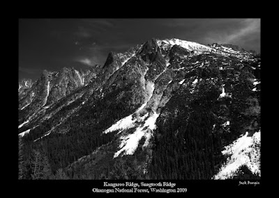
Kangaroo Ridge, Snagtooth Ridge, Okanogan National Forest 2009


We've recently returned from a cruise to Alaska leaving out of Seattle. (Photos from the Cruise can be seen at this blog).

After the cruise ended, we drove up to Washington Pass on the North Cascades Highway (or here for The Cascade Loop commercial website). The long drive was worth it as I took many images of the mountains and lakes. The weather was mostly clear with the low humidity making up for the fact that we were at this point in mid-afternoon which is usually not the best time for the angle of the sunlight.

This image is one of several favorites from the drive. It shows the tail end of Kangaroo Ridge (the ridge in the foreground) and Snagtooth Ridge to the right, Silver Star Mountain on the left. For the ridge names, I must trust my GPS mapping program as the Washington Pass topographic map I have is so old, it does not show the North Cascades Highway (which was finished in 1972).
The area around Washington Pass is one of my favorites. I first drove there in 1999, 2000 returning in 2004. Except for 2004, I've only been in June and the weather then, despite repeat warnings from Seattle friends, June weather has usually (2000 was something of an exception) been very kind to me.
I have, in each June visit, still found snow on the ground near (but not on) the highway. (The Washington DOT website, listed above, tracks the progress of the snow clearing work.) One year, there was still enough snow that cross-country skiiers were enjoying the conditions. By going in August (2004) I learned that there is a great overlook the turnoff for which is at Washington Pass. By August, however, the humidity and afternoon sun washed out any decent chance for a photograph.
I hope someday to again stay near Washington Pass to see these mountains in the early morning or late afternoon sun.

Saturday, April 25, 2009

Mount LeConte, Winter Afternoon Clouds, 2007

I had given a talk about bears to a lodging group in Gatlinburg when I headed home, as I almost always do, via the bypass. I always want to see the view from the two overlooks just in case. I've taken many photographs from each. The clouds were moving quickly. Had I arrived 15 minutes earlier or later this image would not have been taken and I doubt the view would have been anywhere near as dramatic. I remember thinking, at the time, how lucky I was to have been at the right spot at the right time.

While mid-afternoon sunlight is often not the best for landscape photography, the angle of the winter sun on the clouds looking towards LeConte from the overlook just happens to be an exception. Other photographs looking to the left and right from this perspective are washed out due to the angle of the sun.

I'm not shy about modifying images so that they portray the mood experienced at the time but this image required very little modification. Other than to convert to black and white, I only modestly increased the contrast.

Saturday, April 4, 2009

Mount Rundle, Vermillion Lakes, Sunset 2006, Banff National Park

Vermillion Lakes are less than a mile north of the town of Banff (which lies within Banff National Park) on the TransCanada Highway. A well paved road runs north of the three lakes making access easy.

This image was taken the evening of the day we hiked Johnston Canyon (I think I took over 200 images that day). We had visit this area earlier in the day but while the views were beautiful, the photograph results were less than satisfactory because of the angle (more the lack of angle) of the sun combined with thick clouds scattering the light. I can't complain as the same light made for good photography conditions at Johnston Canyon. I looked forward to returning later in the day.

No photograph or series of photographs can adequately portray the scale and motive of Mount Rundle. It is an imposing geological feature visible from all over Banff (the town). According to mountainnature.com:"Few peaks show the dramatic impact of thrust faulting like Mount Rundle. The Mount Rundle Thrust Fault, found at the base of Rundle’s steep eastern slope, allowed massive layers to be pushed eastward several kilometres. Cascade Mountain and the Three Sisters are part of the same thrust sheet." If you look at the town of Banff map I linked to above you'll see that the town lies between Vermillion Lakes and Mount Rundle. Fortunately, the elevation of the lakes permit Rundle to be photographed without either the town or the Banff Springs Hotel in the image.

Thursday, January 29, 2009

Johnston Canyon and Creek, Banff National Park 2006


The day after arriving in Canmore and Banff (from Calgary), we drove up the Bow Valley Parkway to Johnston Canyon, only some 10,000 years old. The hike through Johnston Canyon is unique, much of the "trial" consists of metal walkways bolted to the side of the canyon walls so that you walk along and above Johnston Creek. The trail is pretty much level with one beautiful view after another just on the other side of each turn. There are several falls along the trail.

The afternoon was mostly cloudy, what sun there filtered through a heavy canopy of leaves. That made for the opportunity to take longer exposures of the smoothly flowing creek, capturing the mood perfectly. Of course, with all the photographs, tripod setups each time, I was taking my time along the trail, and enjoying myself immensely.

Tuesday, January 13, 2009

Lower Yosemite Falls, June 2007


Having been to Yosemite in July (2002), I planned a return in 2007, while on the west coast for other family matters. The days spent in the Valley were wonderful, even though marked by an absence of cumulus clouds.

Waterfall amounts were not as strong as they could have been. The snowfall the prior winter was comparatively light but you couldn't tell from the volume of water over the lower of the two Yosemite Falls.

Without clouds in June, the light prevented any hint of the smooth waterfall effect so I concentrated on capturing as much of the spray as the water came over the top of the cliff.

The size of this waterfall is impossible to gauge from this photograph. Before this photograph was taken, however, a man stood on the broken large boulder at the bottom of the falls (not a smart place to stand). In this scale, he was as tall as the "Y" in the title script.